Have you ever wondered why roads are numbered as they are? If not, maybe you should have done - there's a nice system for doing it, and understanding it even has some practical benefit (e.g. preventing you from getting lost).
We'll restrict our attention to the roads in the United Kingdom, except those in Northern Ireland, which have a separate numbering system (but not separate enough: their numbers overlap with the numbers used in Great Britain, and even with each other), and those on the Isle of Man. It hardly seems worth having a different numbering system for an area as small as the Isle of Man, but there is one, and again, it overlaps with the numbering system used for roads on the mainland (although there are no motorways).
The basic idea is that most roads in England and Wales begin with numbers 1, 2, 3, 4, 5 and 6, with London as the hub, and most roads in Scotland begin with numbers 7, 8 and 9, with Edinburgh as the hub. There are three basic types of numbered road: motorways (beginning with an M), A-roads and B-roads. There is actually a fairly rigorous definition of ``motorway'', although I'm not sure exactly what it is - perhaps I should consult the highway code? There are also sections of A-road, such as the A1(M), which have motorway restrictions on them, although these do not need to have numbered junctions (which motorways do). These restrictions ban, among other things, pedestrians, animals, small motorcycles, domus, humus and rus. [Surely some mistake - Ed.]
One might have thought that the first-built road would be numbered 1, the second numbered 2, and so on, but it doesn't work like that, although admittedly the A1 is one of the oldest roads, being reputedly two thousand years old! (Legend has it that it started with someone walking from Edinburgh to London.) No attempt is made to use all the numbers: for example, there is no M7, although after reading this, you'll be able to guess where it would be if it existed. Instead, the number of the road should be thought of as a sequence of formal symbols (such as letters) which just happen to look like numbers. So, for example, the roads which begin with 1 are more closely related to each other than to roads which begin with 2, just as words beginning with A are grouped together in a dictionary.
With the rise in road traffic at the beginning of the 20th Century and the need to provide government funding to improve them, the British government started work on classifying the road system. The First World War interrupted work but it resumed afterwards and in 1919 an Act of Parliament was passed which gave the OK for the Government to fund roads and, in order to do so, they decided to number them.
It was fairly quickly realised that a numbering system would also be useful for navigation. The newly created Ministry of Transport (MOT) set about identifying which roads needed funding, and numbering them. There were to be two classes of roads: A roads, more important with more funding, and B roads of lesser importance.
By 1921 the MOT had identified the system for England and classified 97 main A roads, with one or two digit numbers - some of these were published on Michelin and Bartholomews maps, much to the Ministry's irritation - and to Bartholomew's irritation as some of the numbers then changed.
The formal classification was not published until 1923, in a little booklet published by HMSO. The Ordnance Survey published a series of maps - the MOT series and several other mapmakers published revised road maps. Road numbers also went up on signs.
Numbers changed quite a bit in the 1920s:
The numbering system works as follows.
In England 6 main radial routes out of London were identified:
Working in an clockwise direction roads starting in the zone east of road 1 (A1) were given numbers beginning with 1; south of the A2 numbers beginning with 2, west of the A3 with 3 and so on. There were exceptions - roads starting in North Kent began with 2, and the A40 between the city and marble arch marked the southern boundary of roads beginning with 5.
In Scotland 3 main radial routes out of Edinburgh were identified:
Going clockwise again, roads between the A1 and the coast started with 1, roads between A1 and A7 started with 6 (continuation of the 6 zone) between A7 and A8 with 7, A8 and A9 with 8 and A9 and the coast with 9.
Roads which began in one zone but continued across several others maintained their initial number - thus the A46 begins in zone 4 in Bath, but keeps the same number despite crossing into zones 5,6 and 1 on its way to Grimsby.
The A roads were given two, three or four figure numbers broadly in terms of their importance. All 2 digit numbers, barring 79,89 and 99 were used. Not all 3 digit numbers were used (289-299, 598-599 for example). Some numbers were allocated to roads yet to be built The four digit numbers were mainly given to link roads.
In another twist, some central London roads were given numbers in the sequences 12XX, 22XX, 32XX, 42XX, 52XX.
For B roads the first digit of the number was given according to the same system as A roads. But there were no one or two digit B roads. Also, numbers 100-149, 200-249, 300-349, 400-449 and 500-549 were reserved for use in central London while 150-199, 250-299, 350-399, 450-499 and 550-599 were used for roads starting in outer London. There is one exception - the B259 ran between Brighton and Eastbourne. Because the MOT expected more roads to be built in London B numbers in the series BX90-BX99 weren't used. Once these numbers were used up B roads were all given 4 digit numbers.
The A329(M) at Reading should be the M329, as it runs parallel to the A329. Unfortunately I think I'm the only one who's noticed this despite the fact that it has been around for ages.
[As I recall, the A3(M) from Havant to Waterlooville is another of these: it runs parallel to the A3 - Ed.]
I think that a different system operates for the motorways in England and Wales with two hubs in the vague areas of London and Birmimgham. The zones are thus:
I think Stephen Holt's theory on Motorway numbering requires a modification now that the M48 & M49 have appeared near Bristol. They don't confirm to Stephen's rules 4 and 5 since they are West of the M5 and therefore should be numbered M5-something. Do we need a third ``hub'' in the Bristol area?
On the curve tightness thing. I remember when they built the extension of the M40 north past Oxford - they had to thread the road around a forest and between some SSSIs (no, that is not a cue for an environment debate), and one of the bends was very tight. Apparently the criterion for the design of bends is that cars must be able to safely go around them at the maximum design speed of 120 mph. If they can't, then speed restrictions must be placed on the road. That particular bend has an horrendous camber, and I remember hearing about police cars trying out the bend at 120 mph before the motorway was opened. It was OK, and is apparently the tightest full speed bend on British motorways.
In addition to the comment above, I notice on a map of the M90 between J8 and J9 that the road curves around nearly 180 degrees around Balmanno Hill in Perth & Kinross. It has been a long time since I was last up in that part of GB but I don't remember there being any slower speed restriction. Can this be the sharpest corner on a GB motorway?
On the subject of numbering, this is something which used to fascinate me as a boy when my dad, noting my early interest in his road atlas, explained the UK system of numbering roads to me. On long journeys I would often try to find exceptions to the general rules. The A41 was a favourite of mine (the London to Birkenhead (!) trunk road). Whilst the southern half appeared to justify the 4 numbering (being largely south of the A5), it then crosses the A5 north of Wolverhampton and continues merrily northwards. But even if the logic was that the road ``starts'' in London, it starts to the ``right'' of the A5, and terminates to the ``right'' of the A5, so cannot really justify being in the 4 zone. Interestingly, it runs exactly parallel to the A5 for its first 15 miles from London, and crosses the A5 twice on its way north. Furthermore, in this first leg, it also gets eaten up by the A1 for a short length, which must be a unique achievement for a north-south running 4 road. A further point of interest is the absence of the A6 in the north London area - did the A6 ever reach the capital? It currently ends at Luton, and the oldest map I have shows it ending at the South Mimms junction with the A1 (pre-M25). Presumably it followed the now A1081 through Barnet, but must have then run into the A1 again well north of The City. Thus, we have, from West to East, the A5, the A41, the A1, and the (ex) A6 (in that order) all running parallel north of London - not only completely undermining the numbering system, but doing so only 5 miles after leaving London.
And don't start me on the M54 (all of it south of the A5), or the M62 (starts in zone 5, finishes in 1).
I also wonder what number the new Birmingham Relief Road will get - running virtually alongside the A5, and will it actually get an ``M'' allocation, as Britain's first toll motorway? Any thoughts?
The current line of the A1 from East Finchley to Hatfield is not the original one, but rather the Barnet bypass. The Great North Road follows what is now the A1000 and so the place where the A6 began its journey to Carlisle is the original A1/A6 junction in Barnet, at what is now the A1000/A1081 junction (how the mighty have fallen!). The A41 is more interesting - the original line was along the A4140 to Bushey and then the A411 to the current location of M25 J19a before the new A41 Watford bypass was built. Note that the old road remains to the west of the A5 and is thus in the ``correct'' cone. When the bypass was built, it was obviously not deemed worth money and effort renumbering the whole road up to Birkenhead as A5xxx just because of a few miles of new road. (Does anyone know when these bypasses were constructed? They're both in a 1950s A-Z I have.) I suspect that other inconsistencies in the (A) road numbering system can be explained similarly.
I'm hoping that the Birmingham Northern Relief Road is to be numbered M6, so that the existing M6 through the West Midlands can be renumbered M666...
So what number did Baker Street and Finchley Road have before they were the A41?
Roads that cross zone boundaries (ie over 1-digit A roads) take their first number from the furthest anticlockwise zone they enter. So the A41 either starts or originally started in zone 4.
The M90 Edinburgh - Aberdeen trunkroad passes Perth to the southeast but from junction 10 there is a three mile spur north to join the A9 at Broxden which also purports to call itself the M90. The motorway south from 10 has always been the M90 but if I remember correctly both the east west bits used to be the M85. So if you report to police that you are northbound on the M90 just north of junction 10 they will not know which one you are on.
The basic criterion determining the first digit in a road's number is which ``cone'' (or zone) the road begins in. The cones are numbered 1-6 (for England and Wales) and 7-9 (for Scotland), and are basically defined in terms of the nine key roads A1 to A9 (which do all exist). Roads in England are generally considered to begin from the London end, and roads in Scotland from the Edinburgh end. When the road has numbered junctions (usually because it is a motorway, although there are exceptions, like the relatively new A14), the low-numbered junctions are at the beginning of the road.
As I mentioned, the roads A1 to A6 are considered to start from London. They emerge clockwise starting from the north: the A1 goes to Edinburgh, the A2 to Dover, the A3 to Portsmouth, the A4 goes west to Bristol, the A5 to Holyhead and the A6 to Carlisle. (Note that some of these roads are no longer continuous, since sections of them have been replaced by more major roads: for example, one section of the A5 near London was renumbered, presumably to confuse people into using the M1 instead.) The 1-cone, where the roads begin with 1, lies to the north of London between the A1 and the A2, and so on, ending with the 5-cone between the A5 and the A6, and the 6-cone between the A6 and the A1.
Numbering in Scotland works analogously. The key roads, which emerge clockwise from Edinburgh, are the A7, which goes southwest to Carlisle, the A8, admittedly largely eaten up by the M8, which goes west to Greenock, and the A9 which goes north to Thurso.
This basic plan applies to all the types of road, not just A-roads. However, there are some exceptions, some of them irritating. One of the most striking is the M5. It is usually the case that if a motorway and an A-road have the same number (e.g. the A3 and the M3), then they go approximately in the same direction. However, the M5 is a blatant exception: it goes from Birmingham to Exeter and is clearly very friendly with the A38, which it is essentially replacing throughout its length, so it should be called the M38. The A5, in contrast, is almost at right-angles to the M5!
The M621 (Leeds to Gildersome) in a very real sense joins to M62 to the M1. How many other motorways/A-roads are there for which there exists a partition of the road number into the two roads that it connects?
Of course the M62 itself fails, for it does not join the M6 to the M2. Nor do I count the trivial partition: the M25 should not be regarded as connecting the M25 to the M25, nor should the M6 be regarded as connecting the M6 to nothing (although this probably depends on your opinion of Carlisle).
Well the A46 (which runs right near my house) joins the A4 at Bath to the A6 at Leicester.
Also the A404 (a very strange road which loops round a full semi-circle) runs from the M4 near Maidenhead, across the A4, across the M40 and the A40 at High Wycombe then round and into London where it joins the A40(M) so it joins its partitions in both the motorway and the A road sense!
Yes, there is another one! The A1214 in Ipswich connects the A14 to the south of the town (where at an interchange it begins multiplexing with the A12 east, and eventually northbound) with the A12 to the east of the town. Exiting the A14 into Ipswich at the Copdock interchange, you travel on the A1214 northward, through the north of the town, through Kesgrave and out onto the A12 at Martlesham.
Interesting numerical coincidence: Until the A604 was re-designated A14, I couldn't think of any junction which gave access to a road of the same number as the junction; now I can think of two: M11 J14 is for the A14, and A1(M) J14 is also for the A14.
And another one... M32 J3 joins with the A4320 (which is a relief road to link the end of the motorway to the A4 Bath Road and thus avoid the Bristol inner relief road and city centre). Along its length (about 2 miles) the A4320 has junctions with the M32, A432, A420 and A4. I just wonder if the bods that named the road knew what they were doing and called it the A4320 on purpose just for this very reason.
Is there any system for the allocation of numbers of roads such as the A46 which cross several ``cones''? Why for example is the A46 not the A1xxx as its northerly point at Grimsby) is east of the A1. (I see that it appears to start at the A4 in Bath - and wonder why there should be a route between Grimsby and Bath.)
The A100 and B300 are very short roads in central London, each not much more than 1 mile. The B709 by contrast is a long road which starts about 8 miles south of Edinburgh and ends at Dumfries - a distance of some 50+ miles. Does anyone know of a longer B road?
Stephen Bott answers:I think the B1145 is one of the longest B roads in the country too. If you look, it goes from Kings Lynn to Mundesley (near Cromer).
Surely the M25 is an anomaly to the cone system and ought to be the M0 or perhaps just the M?
The M4 ran across the old Severn Bridge but when the new bridge was built, the new section linking the new bridge to the old road was called M4 and the part excised by this is now the M48. Are there any other examples of M sections being renumbered? [Yes: have a look at the M60 fiasco for a good example! - Ed.]
I cannot see what is wrong with the M25 being numbered as it is. Yes it does not fit into the cone system, but it does run alongside the road it replaced, the A25. Surely this is a good enough reason for the number. It can hardly be called the M414 (the road it runs alongside in the north). Also in a more gentle time, the A25 used to be known as the valley road.
If the two-digit A-roads (12, 57 etc) were originally built as trunk roads crossing large distances (which they were), where on earth does the A38 come into things?! It runs from Bodmin (Cornwall) to Mansfield (S. Yorks) by way of Plymouth, Bristol, Birmingham and Derby. The M5 replaced most of it (so surely that should be the M38) but it's still there.
This is incorrect. The A38 does indeed terminate at Mansfield but Mansfield is nowhere near South Yorkshire as it is well and truly in the county of Nottinghamshire.
As far as I can tell, the A3400 starts at J4 of the M42 and ends where it meets the A44 near Chipping Norton. Thus, despite being numbered as an A3xxx road, its entire length is within the 4 cone of the road numbering system and hence it should definitely have a number beginning with 4 rather than 3.
I wonder if there are any other roads which run entirely outside the cone that their number suggests that they belong in ?
This is probably because the A3400 follows part of the course of the old A34 (hence the name). Furthermore, it must have started in the 3-zone: even if most of it lies in the 4-zone, as long as it starts in the 3s it's okay numberwise. I guess the part within the 3-zone has been downgraded thus giving rising to the apparent anomaly. This is all guesswork, by the way. There are, however, two examples in London that people often bring up. Firstly the A41 which starts east of the A1, i.e. in the 1-zone. Its route was revised many decades ago but it originally started west of the A1, i.e. in the 4-zone. Secondly, the A6, which appears to start in Luton, a mere thirty miles from London. The present A1081 was the A6 a long time ago, so that's that one wrapped up.
Paul just slightly misses my point on the A3400's uniqueness, because although there are several examples of roads which run for very little of their length in their numerical ``home cone'', the A3400 is, as far as I know, the only A- (or for that matter B-) road which runs entirely outside its ``home cone''. I accept the A3400 may, at one time, have run for some of its length (now renumbered or declassified) in the 3 cone but, if so, I can't find any of it in there now and I think this still makes the A3400 unique as things stand. (Different rules, of course, apply to Motorway and C-road numbers.)
Please let me know if you know of any other such anomalies (or, alternatively, if you can confirm that the A3400 is unique in this respect).
I am now able to answer my own question. There is at least one other A-road that runs entirely outside its ``home cone''. This is the A6144 which - along with its sibling, the notorious A6144(M) - runs entirely within cone 5.
The A3400 is NOT unique. The A4601 also never enters its home cone. It was formed when the A460 was re-routed along the Cannock eastern bypass, and is the result of the original route renumbering. It's from the A3400 school of renumbering. Whilst it does start at the A5, it then goes the wrong way (northwards) away from it through Cannock Town Centre, and finally ends up back on the A460 in Hednesford.
We've been discussing this on SABRE in a thread entitled "Roads entirely in the wrong zone", and the answer is definitely yes! Including the A3400, we've now got fifteen entries:
Some of these are due to truncation, some to rerouting of zone boundaries, some are deliberate attempts to create a distinctive number, and some appear to have no explanation at all - they're just careless renumberings. Hope this helps!
I understand you have been in touch with Swansea City Council about the route number of the above mentioned road.
The classificaton of highways and route numbering, where appropriate, in Wales is the responsibility of the National Assembly for Wales, and formerly the Welsh Office. Pentrechwyth/Jersey Road was allocated a classified road status in 1991 and given the number B5444 due to the construction of the Pentrechwyth bypass and cross valley link.
Unfortunately the route number used was not appropritate for use in South Wales, all roads in this area would normally start with the number 4. Also, as you have pointed out, the number was already in use on road in the Mold area. We will be discussing an amendment to the route number with the City Council and once agreed we will inform the map production companies. The City Council will then amend the necessary traffic signs.
Thank you for making us aware of the error.
I [M4 Man] was quite impressed with this reposnse - an admission of guilt from government!
So, that's the first digit of the number explained? What about the rest of the number, you may wonder. The rules for determining the subsequent numbers are necessarily more vague, since not all roads lead to Rome (respectively, London or Edinburgh), but the idea is that the closer to the hub the road starts, the lower the second number should be. The secondary numbers also tend to sweep clockwise round the cone in the same order as the primary numbers. This is well-illustrated by the roads A20 to A24, which essentially start in London. The A20 goes south-east to Folkestone, and the Channel tunnel. The A21 goes to Hastings, which is further to the west; the other roads occur in sequence passing to the west: the A22 goes to Eastbourne, the A23 to Brighton and the A24 to Worthing.
Motorways and B-roads are qualified in a vaguely similar way. The main difference is the number of extra digits which may be added. Motorways usually only have one or two digits, but a few (like the M180) have three. A-roads may have one, two, three or four digits, even if they have motorway restrictions (like the A6144(M) near Manchester). B-roads have three or four digits. The length of a road's number tends to be in inverse proportion to its importance.
One of the high points of my recent honeymoon in the Outer Hebrides was my first sighting of a road sign bearing the number of a classified `C' road: I hadn't known such things existed. It was in the middle of Tarbert on the Isle of Harris, and I was so interested that I took a photo of it! My wife was rather dismissive, suggesting that such things were common in the wastes of Scotland.
It was the C78 to Kyles Scalpay. Rather like most of the back roads on Harris: single track with passing places, rough-edged, tortuously winding... I presume it merited a number because of being the road to the Scalpay ferry, and hence in local terms a ``trunk'' route, but could not in all honesty be classified as a B road. I think they may be building a bridge to Scalpay now, so maybe they'll upgrade the road too.
You might be interested to know that Jersey has an extensive network of C-roads. The map there lists A and B roads (coded green and red, not sure which is which) and yellow C-roads, no Motorways!
There is also a classified C-road running from Lovedean towards Haslemere, I believe. However, since it has been some years since I was there, it is quite possible that I am mistaken as to the origin, the destination and the classification.
Re Matthew Garrett's comment: C roads are still used by Waverley Borough Council (which includes Haslemere). They're published in the paper on public notices for roadworks, like the junction of the C1234 (High Street) and C5678 (Station Road) will be closed for X days (fictitious numbers and places). I think I remember some D roads as well, but could be mistaken.
There are a couple of C-road numbers on road signs on mini-roundabouts on the Southern edge of High Wycombe - somewhere near the arrow on here
I believe that the C-road classification was formerly available for use by County Councils to allow them to identify roads not otehrwise numbered, but regarded as having particular local significance. My recollection is that there was correspondence on this subject in the CTC Gazette (the magazine of the Cyclists' Touring Club) sometime in the 1950s (but possibly in the 1980s). The use of the classification was optional.
Scunthorpe also has 'C' grade road (its number I can't remember off the top of my head) as well as a road sign that tells you to drive on the right hand side of the road. Very odd, and the only one I've ever seen.
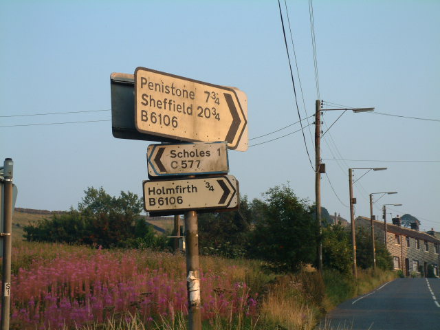
About 1 mile outside Holmfirth on the B6106 (Dunford Road), there is a modern road sign indicating, to the left C577 (and if you go about a mile down that road turning left, you come to a place called Paris).
I've also seen roads with "R" numbers (on roadworks advance-notice signs). Are these for Rural roads that don't have County numbers?